АР22788508 «Development of methodological approaches for monitoring the condition of critical hydraulic infrastructure facilities in Kazakhstan using unmanned aerial vehicles and remote sensing of the Earth»
Relevance
Critically important hydraulic structures play a key role in ensuring water safety, regulating flow, and protecting territories from flooding. Many of them have been in operation for decades and require continuous condition monitoring, as even minor deformations can lead to serious emergency situations. Traditional observation methods do not always allow timely assessment of changes in the structure of dams and other facilities, especially over large areas and in hard-to-reach zones.
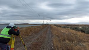
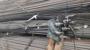
Figure 1 – Carrying out leveling
In this context, the use of modern unmanned aerial vehicles (UAVs) and digital technologies becomes a relevant and necessary tool for enhancing safety.
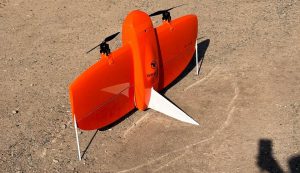
Figure 2 – UAV Wingtra One
The development of methodological approaches to monitoring using UAVs allows for higher accuracy in observations, reduced labor costs, and early detection of potentially hazardous processes.
List of publications for the second half of 2025.
As part of the project, articles were prepared and submitted for publication in high-ranking journals in the Scopus database (Q1, Q2).
Research group
1. Nail Nizametdinov Candidate of Technical Sciences NJSC “Abylkas Saginov Karaganda Technical University “, PhD., Acting Associate Professor
ORCID https://orcid.org /0000-0002-8881-1259
Scopus ID 57191986266
2. Dmitriy Ozhigin, PhD NJSC “Abylkas Saginov Karaganda Technical University “, PhD., Acting Associate Professor
ORCID https://orcid.org /0000-0002-2443-3068
Scopus ID 55827717400
3. Nikolay Kosarev, Associate Professor of the Higher Attestation Commission Research Institute of Geodesy, Topography and Cartography, Czech Republic, Researcher
ORCID https://orcid.org /0000-0003-1806-3651
Scopus ID 57226373393
4. Asel Satbergenova, M.Sc., doctoral student in the specialty “Geodesy” NJSC “Abylkas Saginov Karaganda Technical University “, master, senior lecturer
ORCID https://orcid.org /0000-0001-5806-2827
Scopus ID 5720941133
5. Vera Yartseva, M.Sc., doctoral student in the specialty “Mining” NJSC “Abylkas Saginov Karaganda Technical University “, master, senior lecturer
ORCIDhttps://orcid.org/0000-0003-3015-0280
Scopus ID 59914066200
Web of Science Researcher ID OGO-1858-2025
6. Victoria Kazantseva, candidate for a candidate’s degree in the specialty “Geodesy” NJSC “Abylkas Saginov Karaganda Technical University “, master, assistant
ORCID https://orcid.org /0000-0002-5915-1677
Scopus ID 59552921200
7. Ulpan Kubaidullina, Master of Engineering Science NJSC “Abylkas Saginov Karaganda Technical University “, master, assistant
https://orcid.org /0000-0002-2445-5590
8. Ruslan Baigali, Master of Engineering Science NJSC “Abylkas Saginov Karaganda Technical University “, master’s, assistant
ORCID https://orcid.org /0000-0003-4431-2172
Achieved results in the second half of 2025:
A second series of high-precision leveling was conducted on previously established benchmarks using the Leica DNA03 digital level, which allowed refining the vertical control and verifying the stability of the reference network. Simultaneously, tacheometric observations were performed along profile lines and characteristic elements of the site to detail the planimetric positions of points and enable subsequent comparison with digital models. The second cycle of static GNSS measurements on reference benchmarks using dual-frequency Leica GS14 and GS16 receivers refined the planimetric and vertical positions of the network and enhanced the reliability of geodetic control.
Ten UAV flights with the DJI Mavic 3E were carried out, maintaining consistent survey parameters to ensure comparability of multi-temporal data. For each series, digital terrain and surface models, orthophotoplans, and dense point clouds were generated using Agisoft Metashape software for deformation analysis. Three series of thermal imaging allowed the creation of radiometrically calibrated thermal orthomosaics and temperature maps synchronized with the UAV surveys.
Characteristic points of the site, including benchmarks, building corners, and elements of platforms and slopes, were identified on multi-temporal digital models, ensuring unambiguous temporal identification. The coordinates and elevations of these points were compared with classical geodetic measurements — leveling, tacheometry, and static GNSS. Statistical accuracy indicators were calculated, validating the digital models and quantitatively assessing their suitability for geodetic monitoring and deformation analysis.
Information for Potential Users
As a result of the project, modern methodological approaches for monitoring hydraulic structures will be developed, based on the use of unmanned technologies, high-precision geodesy, and digital modeling. Potential users will gain:
• The ability to apply standardized methods for assessing the condition of dams and engineering facilities;
• Tools for timely detection of deformations and defects, including hidden filtration processes and geometric changes;
• High-precision multi-temporal digital models that allow comparison, forecasting, and trend analysis;
• Recommendations for reducing the risks of emergency situations;
• Solutions that improve the efficiency and safety of facility operation.
The project results are oriented towards practical implementation and can be used by both government agencies and private organizations responsible for the operation of hydraulic facilities.
Scope of Application
The developed approaches and research results can be applied in the monitoring of:
• Embankment and earth dams;
• Hydraulic structures of various purposes — reservoirs, canals, dams, settling tanks;
• Engineering infrastructure facilities requiring stability and deformation control;
• Areas prone to flooding or groundwater level changes;
• Large areas requiring rapid condition assessment without interrupting operation.
The methodologies can be used by design and operating organizations, safety services, government agencies, as well as research centers engaged in ensuring the stability and reliability of hydraulic structures.
Date of information update: 25.12.2025
AP22787307 «Development of technology for supporting mine workings on deep horizons based on the study of the geomechanical condition of rockmass» s.s. – Imashev A. Zh.
The relevance
The development of the mining industry in the Republic of Kazakhstan is accompanied by the commissioning of new horizons for mining, which requires a significant amount of mining capital and preparatory work.
With an increase in the depth of mining operations over 700 m, the solution of geomechanically problems and issues of managing the state of the massif becomes more and more complex, the intensity of deformation processes begins to manifest during the penetration and supporting of mine workings, and the number of cases of roof and side workings collapses also increases. The change in the stress-strain state of the rock mass around the workings at deep horizons occurs due to the action of high stresses on the production circuit.
The penetration of workings at great depths is always accompanied by a redistribution of the initial stress field, while a secondary stress field is formed. One of the main drawbacks in substantiating the parameters of the stability of rock outcrops in the contour part of the massif is the lack of knowledge of geomechanically processes. The reason for this is that the models used to describe geomechanically processes that occur near a rock mass of man-made outcrops do not quite correctly reflect the size of inelastic deformation zones.
Despite the large amount of theoretical and experimental research according to the assessment of the stress-strain state of the rock mass around the mine workings, there is still no final scientifically based approach to reliably determine the zones of inelastic deformations, especially at deep horizons. Ensuring the safety of mining operations is achieved by correctly justifying the geomechanically state of the massif and calculating the load on the support of mining workings. It is necessary to apply the experience of foreign countries, where the problems of rock stability are solved using the results of research that have practical testing at deposits based on rating classifications of rock quality.
Based on the analysis and review of the issue, the purpose of scientific and applied work is formulated – to determine the parameters of the zone of inelastic deformations around the workings at deep horizons, taking into account the fracturing of rocks, depending on depth of location and shape section of the workings, physical and mechanical properties and modulus of elasticity of rocks for the selection of types and parameters of fastening in accordance with the rating classifications of the rock mass.
The assessment of the power of zones of inelastic deformations during the penetration and supporting of mine workings in the mines of Kazakhstan, especially at depths of mining operations over 700 m, necessary for assessing the stability of the rock mass containing the mining, planning mining operations, choosing the parameters of support and fastening systems of workings, is currently not carried out or is methodically unreliable. Therefore, the prediction parameters of zones of inelastic deformations during the penetration of preparatory mine workings at deep horizons is an urgent scientific and practical research task.
Research Results in the 2-nd half of 2025:
Under mine conditions, investigations were carried out using a video endoscope to assess the development of fracturing in the vicinity of underground excavations at great depths. Field observations are one of the key methods for studying geomechanical processes occurring within a rock mass. Without such observations, it is impossible to accurately identify the principal influencing factors, which complicates the formulation of tasks for subsequent analytical analysis and numerical modeling.
In order to investigate the behavior of the rock mass in the near-contour zone of underground excavations, the following field research methods were applied:
• visual monitoring of fracture development;
• instrumental measurements at control sites using a geological compass and an electronic measuring tape.
Visual observations made it possible to assess the general state of fracturing and the degree of disturbance of the rock mass in the vicinity of the excavations. For a more precise characterization of fracture formation processes, instrumental measurements were performed at specially organized observation sites. These data provided reliable information on the fracture intensity of the rock mass and the specific behavior of the surrounding rocks within the zone influenced by the excavations.
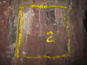
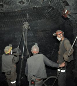
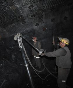
Observations were conducted in underground workings at the +96 m level, at a depth of approximately 250 m. In total, nine observation sites were equipped (Figure 1). At each site, a surface fragment measuring 1 × 1 m was delineated.
 |
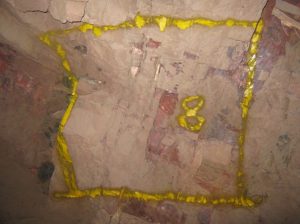 |
Figure 1 – Observation sites No. 2 and No. 8
The reduction in rock strength within the mass caused by fracturing is evaluated using the structural weakening coefficient Ks, which is defined as the ratio of the cohesion of the rock when it detaches from the rock mass (under fractured conditions) to the cohesion of the same rock determined on an intact laboratory specimen. Typically, cohesion along fractures and tectonic discontinuities in igneous and metamorphic rocks ranges from 0.05 to 0.1 MPa. However, the cohesion developed along fractures and weakened zones may be higher, depending on the roughness of fracture surfaces and variations in their orientation.
According to the results of geotomographic scanning, the depth of development of the conditional fractured zone within the rock mass averages between 1.0 and 1.3 m. This conclusion is based on the position of the high-frequency reflection line recorded within this depth interval.
It has been established that when fracture density is up to 10 fractures per meter, the extent of the disturbed zone reaches approximately 1.0 m. As the number of fractures increases to 20–25, the depth of this zone increases to about 1.3 m.
List of publications for the 2-nd half of 2025
1) A patent application for the invention titled «Frame Hinged Support Made of Box-Section Profile», authored by A.Zh. Imashev, A.M. Suimbayeva, A.A. Musin, A.K. Mataev, G.B. Eskenova, N.K. Shaike, and G.Zh. Zhunusbekova, has been submitted for expert review
Research Team
1.Askar Zhanbolatovich Imashev – Scientific Supervisor, PhD, Head of the Department «Development of mineral deposits»
Researcher ID – ABC-2138-2021;
ORCID – 0000-0002-9799-8115;
Scopus Author ID – 57204153972.
2. Suimbayeva Aigerim Maratovna – PhD, responsible executor, Acting Associate Professor of the Department «Development of mineral deposits»
Researcher ID – AAC-8234-2022;
ORCID – 0000-0001-6582-9977.
3. Musin Aibek Abdukalykovich – PhD, еxecutor, Acting Associate Professor of the Department «Development of mineral deposits»
Researcher ID – AGD-8697-2022;
ORCID – 0000-0001-6318-9056;
Scopus Author ID – 57225333744.
4. Matayev Azamat Kalizhanuly – PhD, еxecutor, Acting Associate Professor of the Department «Development of mineral deposits»
Researcher ID D-3766-2019;
ORCID – 0000-0001-9033-8002;
Scopus Author ID – 57219561578.
5. Zhunusbekova Gaukhar Zhumashevna – еxecutor, Master of Technical Sciences, senior Lecturer of the Department «Development of mineral deposits»
Researcher ID – AAE-8004-2022
ORCID – 0000-0003-2842-270X
Scopus Author ID – 57919123700
6. Shaike Nurlan Kanatuly – еxecutor, Master of Technical Sciences, senior Lecturer of the Department «Development of mineral deposits»
Researcher ID – HLH-4610-2023,
ORCID – 0000-0002-2395-4566,
Scopus Author ID – 58220559500
7. Yeskenova Gulnura Berikovna – еxecutor, Master of Technical Sciences, senior Lecturer of the Department «Development of mineral deposits»
Researcher ID – АВС-2138-2021
ORCID – 0000-0001-8184-4085
Scopus Author ID – 58191278200
Information for Potential Users
The subject of the research comprises domestic mining enterprises where the depth of mineral extraction has reached 800 meters or more. As of now, mining operations at the Orlovsky and Artemyevsky mines are conducted at depths exceeding 800 meters. In addition, a number of underground mines — «Voshod» (LLP «Voshod-Oriel»), «Ushkatyn-3» (JSC Manganese of Zhairem), and «Western Karazhal» (LLP «Orken») — are also projected to operate at greater depths in the near future.
Area of Application
Mining industry, specifically underground mine workings developed at depths of 800 meters and beyond.
Date of information update: 25.12.2025
AP22785093 “Research and justification of mine workings supporting technology with increased rock arching zones stability control while thick coal seams mining”
Scientific supervisor – Khalikova Elvira Ravilovna, PhD, Associate professor of the “Development of Mineral deposits” department.
Relevance
Increasing mining depths with relatively low rock strength and the use of supports with insufficient bearing capacity and structural flexibility are the main reasons for the unsatisfactory condition of mine workings. An analysis of mining operations in the Karaganda Basin shows that significant potential exists for increasing labor productivity and reducing coal production costs due to inconsistencies between seam development methods and the mining conditions they are used for, the increasing complexity of mining and geological conditions during seam extraction as mining operations deepen (the presence of tectonic faults, increased gas content, etc.), capacity imbalances across related technological links and processes, and so on. Taken together, these factors lead to reduced reliability of mining operations and, consequently, to economically unjustified expenditures. The use of the noted reserves is especially important when implementing progressive technological schemes for conducting mine workings and designing progressive technology for developing thick gas-coal seams with complex mining and geological conditions.
The issue of mine working stability remains one of the most pressing and determines the efficiency of coal mines in various basins of the Republic of Kazakhstan. This requires the following scientific and applied research and work:
– it is necessary to make well-founded technological decisions to determine the parameters of the support in areas of increased rock arching;
– to provide a geomechanical predictive assessment of the deformed state of the rocks of the host mountain range on thick coal seams;
– develop and implement technology and means with justification of the parameters of their fastening, taking into account the stress-strain state of the host rocks.
Currently, the prospects for the development of the presented scientific direction for underground work in the coal industry of the Republic of Kazakhstan depend on the use of the results of scientific and applied research and the implementation of pilot industrial testing of promising developments in the coal mines of the Karaganda basin.
Results achieved in the second half of 2025:
Technical recommendations have been developed for the formation of process flow diagrams in the zone of influence of geological disturbances during the development of layers of thick seams.
List of publications for the second half of 2025:
– E.R. Khalikova, A.E. Zhumabekova, D.S. Syzdykbaeva, M.G. Mustafin. Tau zhynystarynyn alsiregen aimagyn nygaytu zhonindegi tehnologiyal schemlardy Azirleu. Mining magazine of Kazakhstan. 2025. No. 2. 50-60 https://doi.org/10.48498/minmag.2025.238.2.003
– Syzdykbaeva D.S., Khalikova E.R. Technological conditions for ensuring the stability of the host rock mass during mine working support. Copyright. Application No. 53703 dated January 21, 2025
– Vladimir Demin, Elvira Khalikova*, Tatyana Demina, Dinara Syzdykbaeva, Aibolat Karatayev, Murat Mustafin. Assessment of the stress-strain state of the rock mass surrounding cutting workings during coal seam mining // Mining of Mineral Deposits. – ISSN 2415-3443 (Online), ISSN 2415-3435 (Print). – Volume 19, Issue 2, 2025. – P. 38–46. DOI:https://doi.org/10.33271/mining19.02.038
– Demin VF, Khalikova ER Mountain range geomechanics while developing preparatory mine workings// Monograph – Karaganda: Publishing house of the NJSC “Abylkas Saginov Karaganda Technical University”, 2025, 223 p., ISBN 978-601-355-490-7
Research group:
1. Khalikova Elvira Ravilovna – Scientific supervisor, PhD, Associate professor of the “Development of Mineral deposits” department, Scopus Author ID: 57212216553, Researcher ID Web of Science: ABE-4117-2021, ORCID ID: 0000-0003-1501-8492;
2. Karataev Aibolat Dulatovich – Person in charge, PhD, Associate Professor of the “Development of Mineral deposits” department, Scopus Author ID: 56996048900, Researcher ID Web of Science: AAC-4903-2020, ORCID ID: 0000-0003-2901-7562;
3. Abekov Ulan Erlanovich – PhD, Head of the Production Department of JSC “Maker” Karaganda Foundry and Machine-Building Plant (KLMZ), Scopus Author ID: 57209737940, ORCID ID: 0000-0001-6686-4926;
4. Syzdykbaeva Dinara Seitkalievna – Doctoral student of the MD-23 group of the “Development of Mineral deposits” department, teacher of the LS and EP department, Scopus Author ID: 58973495800, ORCID ID: 0000-0002-0673-0384;
5. Khamze Askar Muratuly – Doctoral student of the MD-25 group of the “Development of Mineral deposits” department;
6. Baigaraeva Bagdat Abdikasymovna – M.Sc., Head of the Office;
7. Zhamelov Rakhat Zhamiuly – M.Sc., chief engineer (for current planning) of the State Production Enterprise JSC “Maker” of the Karaganda Foundry and Machine-Building Plant (KLMZ).
8. Bodaubek Abylaikhan Bakhlatuly – M.Sc., production preparation engineer at JSC “Maker” of the Karaganda Foundry and Machine-Building Plant (KLMZ).
Information for potential users:
The project will enable the effective application of advanced technology for maintaining the contours of mine workings based on established patterns of rock behavior during the development of thick seams, thereby increasing the efficiency and safety of underground mining operations.
Existing technological risks are also reduced due to the use of efficient technology, equipment and fastening means for conducting mine workings and making it possible to avoid the influence of manifestations of mining factors on the operational reliability of the execution of the processes of the tunneling cycle.
Application area:
Mining production in the coal industry with the dissemination of the acquired scientific and technical potential to underground mining enterprises.
 |
 |
Date of information update: 25.12.2025